The Basics of Celestial Navigation, Part 7: Three Lines Walk into a Bar
Three lines, one small triangle: plotting a planet and two stars.

- Introduction: why we want a backup to GPS
- Part 1: The math that makes the world go round
- Part 2: Turning sunshine into math (working a Sun sight)
- Part 3: Connecting the dots (plotting a running fix)
- Part 4: High noon, low math (latitude by noon sight)
- Part 5: Finding the second star on the right (identifying stars and planets)
- Part 6: The Sun clocked out, but the math didn’t (working star and planet sights)
- Part 7: Three lines walk into a bar (plotting a three-body fix) (you are here)
The table work is done. Now we can put those numbers on paper.
A planet sight gives us a line of position, just as a star or Sun sight does. This time we will use one planet and two stars to draw three lines. In a perfect exercise they would all pass through one point. On a moving boat, with a sextant in our hands, perfection may be asking a bit much. A small triangle is still a pretty good indication of where you are.
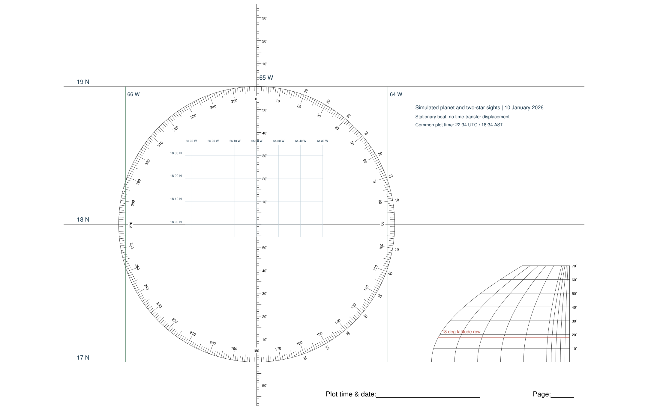
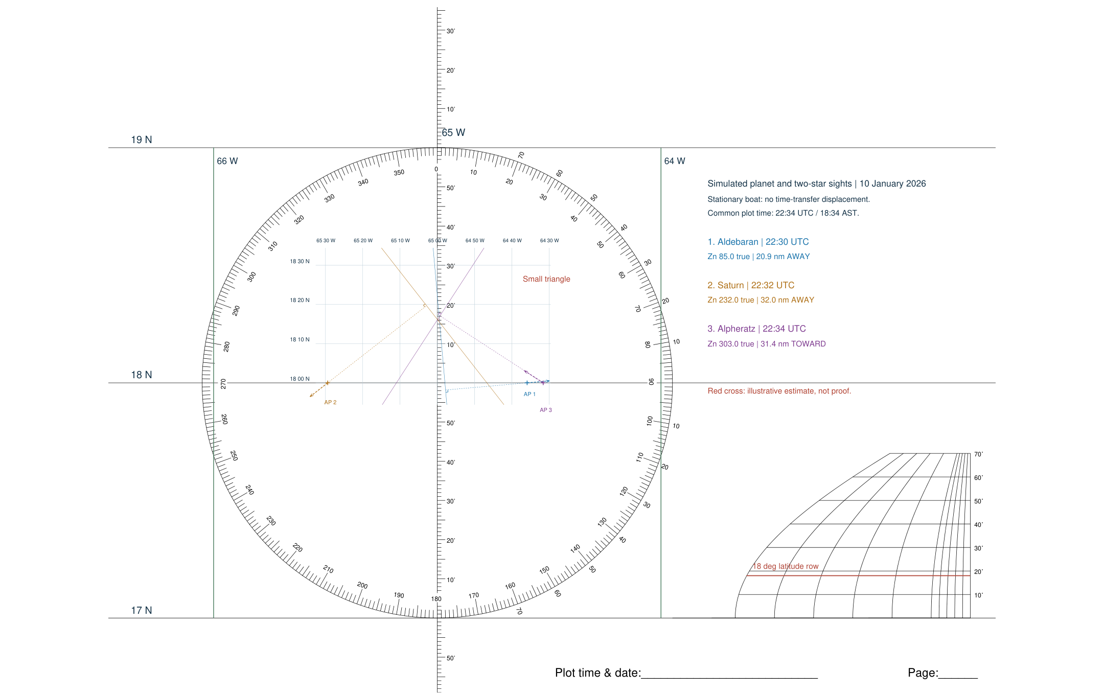
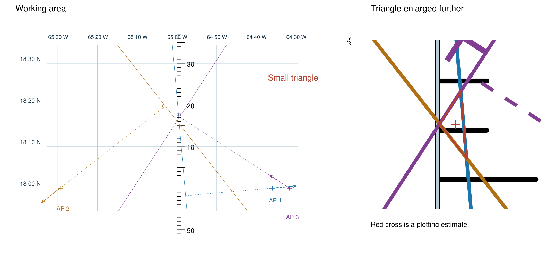
We will use the same Universal Plotting Sheet as Part 3. Each image shows the whole sheet with the next set of marks added, and the last one is a close-up of the working area.
This 10 January 2026 simulation assumes a stationary boat at 18°15′ N, 65°00′ W near St Thomas. That is the reference used to construct the exercise, not a fix from the first sight or an answer we should force the lines to fit.
The three bodies are Aldebaran, Saturn and Alpheratz: two stars and one planet. These are Part 6’s plotting inputs. I’ve built small errors into the simulated sights so the lines form a triangle, as real ones do. These aren’t observations made aboard Neverland.
| Body and sight time UTC | Assumed position | True azimuth Zn | Intercept |
|---|---|---|---|
| Aldebaran · 22:30 | 18°00′ N, 64°35.9′ W | 085° | 20.9 nm Away |
| Saturn · 22:32 | 18°00′ N, 65°29.4′ W | 232° | 32.0 nm Away |
| Alpheratz · 22:34 | 18°00′ N, 64°31.6′ W | 303° | 31.4 nm Toward |
The APs are convenient positions chosen for the table work, not three estimates of where the boat actually is. The fairly long intercepts for Saturn and Alpheratz are not thirty-mile errors in the sights. Each measures the distance from its own convenient AP to its line of position.
Keep the reduction beside the plot
Here is a compact reminder of the reductions from Part 6. Hs is the simulated sextant reading; Ho is its corrected altitude. Hc is the computed altitude for that body’s own AP. The last step involves subtraction, but I think we can handle it: a = Ho − Hc. Positive means Toward; negative means Away.
| Body | Simulated Hs | Corrected Ho | Computed Hc | Ho − Hc |
|---|---|---|---|---|
| Aldebaran | 45°52.9′ | 45°49.1′ | 46°10′ | −20.9′ |
| Saturn | 56°57.5′ | 56°54.0′ | 57°26′ | −32.0′ |
| Alpheratz | 67°33.7′ | 67°30.4′ | 66°59′ | +31.4′ |
The exercise uses zero index correction and −2.9′ dip for all three sights. The remaining altitude corrections are −0.9′, −0.6′ and −0.4′ respectively. Saturn uses the Stars and Planets correction described in Part 6, not a Sun limb correction. Its GHA also comes from the planet reduction, not a star’s SHA. One minute of intercept corresponds to one nautical mile. Keep each row with its own time and AP from the first table.
First agree on the time
Three bodies do not make time disappear. Each line belongs to the instant its sight was taken.
Here the sights are at 22:30, 22:32 and 22:34 UTC, or 18:30, 18:32 and 18:34 AST. Because the boat is stationary in this exercise, we can compare the lines at 22:34 UTC without moving any of them. We still reduce each sight for its own recorded time. “Stationary” does not mean we can use one time for all three bodies.
If the boat were moving, we would first bring the lines to a common time. To use the last sight time, advance the first two lines by the estimated course and distance made good between their respective sight times and 22:34. Move each whole line parallel to itself, just as in Part 3. Do not move all three by the same distance, and do not rotate them.
For perspective, at 6 knots the boat travels 0.4 nm in four minutes and 0.2 nm in two minutes. That is already comparable to a small plotting triangle. Use movement over the ground, including the best estimate of current and leeway, rather than assuming that heading and speed through the water tell the whole story.
1. Set up the same sheet
Label the middle parallel 18° N, the upper one 19° N, and the lower one 17° N. Label the central meridian 65° W. North is up; west longitude increases to the left.
Use the 18° row of the original longitude scale for the longitude spacing. One degree of longitude at this reference latitude occupies 60 × cos 18° = 57.06 nm on the latitude scale. The neighboring meridians are 66° W on the left and 64° W on the right. These are the same construction and scale conventions we used in Part 3.
I have added light ten-minute guide lines in pencil around the working area. Keep the compass rose visible. We need it for the bearings.
2. Plot Aldebaran
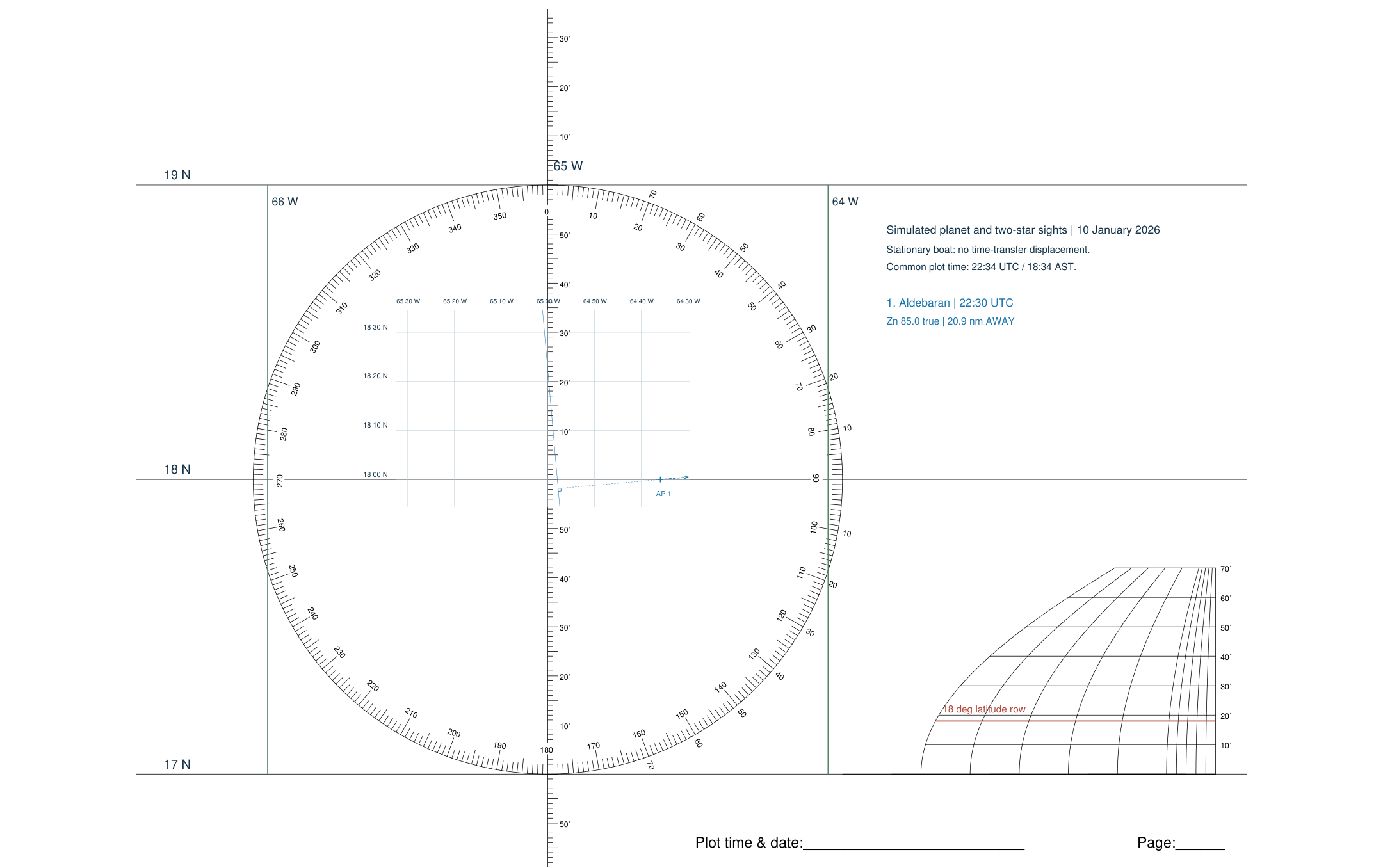
Aldebaran uses AP 1: 18°00′ N, 64°35.9′ W. That is 24.1′ of longitude east of 65° W, so measure to the right of the central meridian along the 18° N parallel. Its azimuth is 085° true and the intercept is 20.9 nm Away. Mark the intercept 265° true from AP 1, opposite the star. The blue LOP runs 175°/355° true through that mark.
Use the longitude scale to place the AP, but use the latitude scale for the intercept distance. That distinction is worth repeating. Longitude minutes get the AP into the right place. Latitude minutes measure nautical miles.
Draw the body's true azimuth through its AP. Measure the intercept in the indicated Toward or Away direction, then draw the line of position at right angles through that intercept point. Label the line with the body and sight time. The azimuth line is a construction line, not the line on which the boat lies.
3. Add Saturn
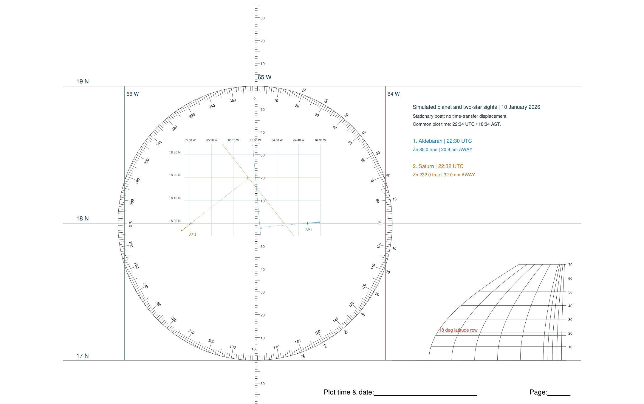
Saturn uses AP 2: 18°00′ N, 65°29.4′ W, or 29.4′ of longitude west of 65° W. Unlike the other two APs, this one goes to the left of the central meridian. Its azimuth is 232° true, but the intercept is 32.0 nm Away. Move 052° true from AP 2 by 32.0 nm, opposite Saturn. The amber LOP runs 142°/322° true through that point.
Each body keeps its own AP. Even though all three sights were taken from the same boat, the convenient longitude used for the table lookup may be different for each one. Do not start the second body's intercept at the first body's AP just because it is already marked.
The two lines now cross. That is useful, but we have a third body, so let's use it. Leave everything we have drawn in place.
4. Add Alpheratz
Alpheratz uses AP 3: 18°00′ N, 64°31.6′ W, or 28.4′ of longitude east of 65° W. Its azimuth is 303° true and its intercept is 31.4 nm Toward. This time we measure along the azimuth, northwest from AP 3. The purple LOP runs 033°/213° true through the intercept point.
Same procedure again: correct AP, true bearing, signed intercept, perpendicular line. The arithmetic may have changed, but the plotting has not.
The three bearings look in substantially different directions. That makes the crossing geometry more useful than three nearly parallel lines would be. It does not make the observations error-free.
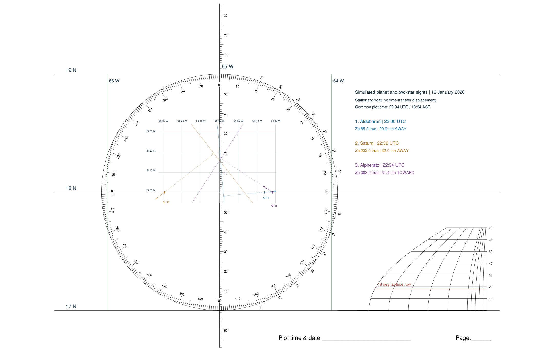
5. Look at the triangle before choosing a point
The little triangle is a cocked hat. It shows disagreement between the lines, not proof that the boat lies inside it.
Check body identification, UTC, instrument corrections, table entries, each AP, intercept signs and plotting. If underway, check the transfers to a common time. A large triangle calls for investigation. A small one is encouraging, but a shared error can shift all three lines without making the triangle large.
Our triangle has sides of about 0.8, 0.9 and 1.4 nm. I have marked its centroid, found by averaging the positions of its three corners. That’s a simple, repeatable choice for teaching, not a rule that the center of every triangle is the best fix. It does not account for differing sight quality or systematic errors.
Read latitude on the central meridian. Transfer the horizontal longitude offset to the 18° row of the longitude scale. The estimate is 18°16.1′ N, 64°59.6′ W at 22:34 UTC. It lies east of 65° W, so its west longitude is slightly smaller.
The estimate differs from our simulation reference. Sight errors, table rounding and plotted azimuths leave a discrepancy; we do not slide the lines to hide it.
A closer look at the same three lines
Here is the same plot enlarged, so the triangle is easier to see.
What I would write in the log
10 January 2026, 22:34 UTC / 18:34 AST. Simulated three-body plotting estimate: 18°16.1′ N, 64°59.6′ W. Aldebaran, Saturn and Alpheratz; individual sights 22:30–22:34 UTC. Stationary exercise, so no motion transfers applied. Small cocked hat; longest side about 1.4 nm. Centroid used as an illustrative estimate.
The point is a working estimate, not a claim that we know our position to a tenth of a mile. Keep the sight times and reductions with the plot so we can see how we got there. Compare it with the DR, other available position information, and the conditions under which the sights were taken. An unexplained disagreement deserves attention even when the triangle looks nice.
Three bodies give us a useful check that a single line cannot provide. The job is still the same: measure carefully, reduce carefully, plot carefully, and resist the temptation to make the answer look better than the observations justify.
That’s the whole series. Start again from the introduction.