The Basics of Celestial Navigation, Part 4: High Noon, Low Math
Finding latitude with a noon sight: fewer numbers, no sight-reduction tables.

- Introduction: why we want a backup to GPS
- Part 1: The math that makes the world go round
- Part 2: Turning sunshine into math (working a Sun sight)
- Part 3: Connecting the dots (plotting a running fix)
- Part 4: High noon, low math (latitude by noon sight) (you are here)
- Part 5: Finding the second star on the right (identifying stars and planets)
- Part 6: The Sun clocked out, but the math didn’t (working star and planet sights)
- Part 7: Three lines walk into a bar (plotting a three-body fix)
In Parts 2 and 3, we worked through a Sun sight and used it to plot a line of position. Now we can look at a simpler way to find our latitude: a noon sight. We still need the sextant and the almanac, but we can put Pub. 249 and the plotting sheet away for this one. There are fewer numbers to look up. The last step involves subtraction, but I think we can handle it.
There is a catch, of course. A noon sight gives us latitude, so we still need another way to find our longitude. And although we will watch the Sun reach the top of its path, picking the time of its highest reading is not as straightforward as it might sound. Let's start with what we mean by noon.
Noon by the Sun
The noon we want is local apparent noon, usually shortened to LAN. This is when the center of the Sun crosses our meridian, the north–south line through the point directly overhead. Think of it as noon by the Sun rather than noon by the ship's clock. Where we are in our time zone makes a difference, and the Sun's schedule shifts a little through the year as well.

At this crossing, called upper meridian passage, the Sun is due north or south of us, unless it is directly overhead. Remember zenith distance from Part 1? It is the angle left between the Sun and straight up: z = 90° − Ho. At noon, that angle lies along our meridian. Once we know the Sun's declination, we have what we need to work out our latitude.
When to take the sight

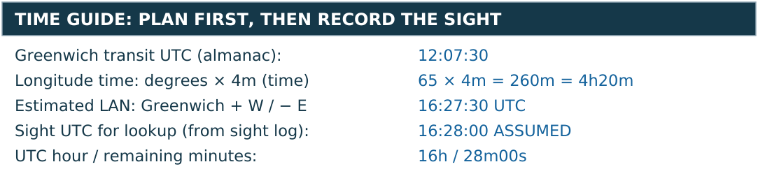
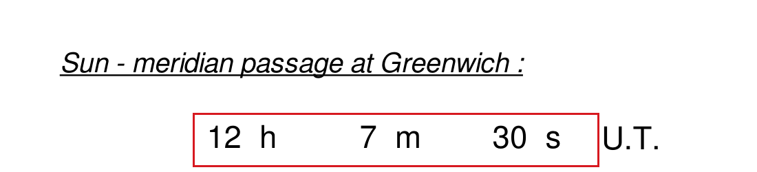
Let's go back to 10 January 2026 near St Thomas. First we need to know roughly when to be ready. The almanac’s date page gives the Sun's meridian passage at Greenwich as 12:07:30 UTC. To turn longitude into time, start with Earth's 360° rotation in 24 hours: 360 ÷ 24 = 15° per hour, or 4 minutes per degree. Our 65° west longitude gives 65 × 4 = 260 minutes, which is 4 hours 20 minutes. The Sun reaches a west longitude later than Greenwich, so we add that time to get 16:27:30 UTC, or 12:27:30 AST. That longitude adjustment describes the Sun's travel from Greenwich to our meridian, not a time-zone conversion; converting UTC to AST is the separate four-hour subtraction. Call it about 12:28 AST for planning. The Sun's apparent motion varies slightly, so this is an approximate window, not an exact appointment. An error in our estimated longitude shifts it too.
Start taking readings before the expected noon and keep going through it. For each one, bring the Sun's lower edge to the horizon, gently rock the sextant to find the vertical angle, and record Hs and the UTC time. Keep using the same limb and a consistent horizon. The readings should rise, seem to pause, and then fall. Don't stop as soon as two readings look the same; keep watching until you can see that the Sun is coming down.
What we're looking for is the pattern in the readings. One unusually high number may simply be a poor sight, so don't automatically choose it. Around noon the Sun seems to hang at almost the same height, which makes its exact peak time hard to pick. Even from a fixed position, the Sun's changing declination means that its highest point and meridian crossing aren't quite the same instant. For ordinary sextant work the peak is a useful approximation to noon altitude, but it isn't a precise clock signal.
The Neverland LAN worksheet
Start with the sextant reading
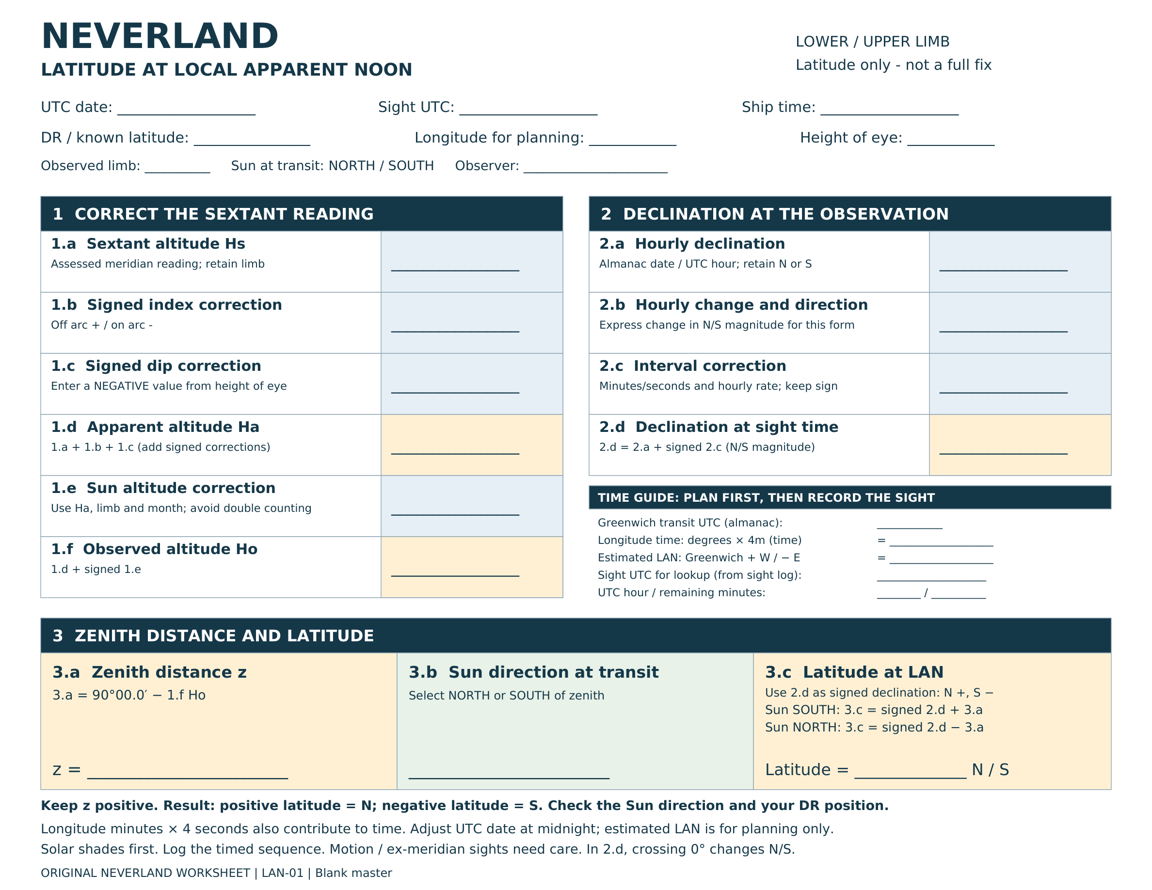
I've kept the Neverland noon worksheet to three sections: correct the altitude, find the declination, and calculate latitude. Blue cells are for inputs, yellow cells are for results, and the green cell records whether the Sun is north or south of us. We'll fill in each section below.
Let's start with the sextant reading. As before, Hs is what we read on the instrument, while Ho is the corrected altitude we need for the geometry. We still have to account for the instrument, our height above the water, and the Sun correction. The shorter calculation at the end doesn't change those first steps.
We'll use a lower-limb reading of 49°39.3′, with zero index correction and a height of eye of 9 ft for this exercise.

Put Hs 49°39.3′ in 1.a, index correction 0.0′ in 1.b, and dip −2.9′ in 1.c. Remember, we found the dip correction from the table in the back of the almanac. Adding those gives us Ha in 1.d: 49°39.3′ + 0.0′ − 2.9′ = 49°36.4′. Ha is the apparent altitude, after the instrument and dip corrections. This is the number we'll take into the refraction table.
Apply the Sun correction
As in Part 2, we find refraction and the lower-limb semidiameter correction separately in the almanac, then add them together for 1.e. That total takes us from Ha to Ho in 1.f.
Our Ha of 49°36.4′ falls between the printed rows 47°04′/−0.8′ and 50°39′/−0.7′. Interpolating between them gives −0.7′ when rounded. The January lower-limb correction is +16.3′, so 1.e is −0.7′ + 16.3′ = +15.6′. Add that to Ha for 1.f: Ho = 49°36.4′ + 15.6′ = 49°52.0′.


With Ho in hand, we can fill in 3.a. Subtract it from 90° to get zenith distance: z = 90°00.0′ − 49°52.0′ = 40°08.0′. If the borrowing looks awkward, write 90°00′ as 89°60′ first. That 40°08.0′ is the angle between our latitude and the Sun's declination at noon.
The time for our almanac lookup
There are two times to keep straight here. The estimated LAN tells us when to be ready with the sextant. The time we use in the almanac belongs to the noon sight we assess from our recorded sequence. Calculating when we expect noon doesn't tell us when we actually took the sight.
The worksheet's time guide keeps those steps separate. Start with Greenwich meridian passage from the almanac. Convert longitude to time using degrees × 4 minutes, plus any minutes of longitude × 4 seconds. Add that time for west longitude or subtract it for east longitude. Adjust the UTC date if the calculation crosses midnight. The answer is our estimated LAN in UTC; converting to the ship's clock is a separate step.
In this example, 12:07:30 + 4h20m gives an estimated LAN of 16:27:30 UTC. That gives us a window for taking a sequence of sights. During a real session, record each reading and its UTC time, then use the time associated with the meridian altitude you've assessed. Don't copy the prediction into the sight-time box or choose an isolated highest reading just to obtain a time.
For this exercise, we'll assume a sight time of 16:28:00 UTC on 10 January 2026. We don't have an actual sight log, so this is a teaching assumption, not a measured time. It is separate from our calculated estimate of 16:27:30. When the next section says about 16:28 UTC, it refers to this assumed sight time.
Write that sight time in the guide, then separate it into the whole UTC hour and the minutes and seconds remaining: 16h and 28m00s. The 16h entry selects the daily Sun row for declination. The remaining 28 minutes select the correction panel. This is how the sight time, rather than the planning estimate, leads us to the almanac entries.
The Sun's broad peak can leave some uncertainty in the time associated with our noon altitude. Record that honestly. A minute near noon makes little difference to this latitude calculation, but peak timing is a poor way to find longitude. If a sight is taken away from meridian passage, it needs an ex-meridian correction or an ordinary sight reduction.
The almanac entries for noon
Here are the actual entries we'll use from the 2026 almanac.


Get the declination and calculate latitude

For our example, use about 16:28 UTC. Start with the 16h Sun row on 10 January and put 21°53.2′ S in 2.a. The hourly change, vd, is +0.4′ northward. Since the Sun is south of the equator, moving north makes its south declination smaller. On this form, enter that change as −0.4′ per hour of south declination in 2.b. The 28-minute panel gives a correction of 0.2′ for a rate of 0.4′. Put −0.2′ in 2.c, leaving 21°53.0′ S in 2.d. The table has done the multiplication for us.
Now we can see why this example is so simple. The Sun is south of us at noon. Its GP is south of the equator and we are north of it, so the angle between us includes both the Sun's south declination and our north latitude. Take the south declination away from z, and what's left is our latitude.
Select SOUTH in 3.b. The rule printed in 3.c says to add z to signed declination when the Sun is south. South declination is negative, so latitude = −21°53.0′ + 40°08.0′ = +18°15.0′, or 18°15.0′ N. This is the same as 40°08.0′ − 21°53.0′. To borrow for that subtraction, write 40°08′ as 39°68′. We are back at the practice latitude we started with, as intended for this example.

What if the Sun is north of us
We've found latitude at the time of the noon sight. The 65° W longitude we used to decide when to start observing is still just our starting assumption. This calculation hasn't checked it.

The subtraction we just used works for our St Thomas example, but we need a rule that works elsewhere too. The easiest way to keep track is to treat north declination as positive and south declination as negative, while leaving z positive. With the Sun south of us at noon, latitude = declination + z. With the Sun north of us, latitude = declination − z. A positive answer means north latitude; a negative answer means south. These are the same relationships behind the usual same-name and contrary-name rules, with the Sun's direction written out explicitly.
A few things to watch for
The Sun is not always to the south
It's easy to get used to looking south for the noon Sun, but that won't always work in the tropics, even north of the equator. Suppose declination is 20° N and the Sun is north of us with z = 10°. Our latitude is 20° − 10° = 10° N. Or suppose declination is 10° S, with the Sun north of us and z = 20°. Then latitude is −10° − 20° = −30°, or 30° S. Check the Sun's direction and your rough position before choosing which calculation to use.
Near the zenith
If our latitude and the Sun's declination are nearly the same, the Sun will pass close to overhead. That can be a difficult sight: the direction changes quickly and handling the sextant at such a high altitude takes practice. The broad rounded peak in the earlier sketch doesn't describe an overhead passage well. Exactly overhead, z would be zero and our latitude would equal declination, but recognizing and measuring that moment isn't an easy shortcut. For a first attempt, choose a day when the noon Sun will be a little lower.
A moving boat changes the problem
So far we've stayed in one place. Underway, the boat adds another complication. Moving north or south changes our distance from the Sun's GP while we're watching, which can shift the highest reading away from meridian passage. Moving east or west changes the time of the crossing too. To use a noon sight underway, we need a method that allows for that movement and for how far the sight is from transit. We can also reduce the observations as ordinary sights, using the method from Part 2.
The same caution applies if clouds interrupt the sequence. A reading taken several minutes before noon needs an ex-meridian correction, or a normal sight reduction, before we can use it. We can't simply call the last reading we managed to get our noon altitude.
Latitude is still only one coordinate
What we have at the end is a check on latitude, along with the time and our judgment of how good the observation was. We still need longitude for a full fix. Because the Sun stays near its highest altitude for a while, timing the apparent peak is a poor way to find that missing coordinate. Use a separate longitude method or another well-timed sight rather than relying on the clock time of the highest reading.
For practice, start somewhere you know, take a series of sights, and see how your calculated latitude compares. That gives you a chance to work on the observation as well as the arithmetic. Once you're comfortable with it, a noon sight is another useful way to check where you are, with rather less page turning than our first Sun sight.
Next in the series: Part 5: Finding the second star on the right (identifying stars and planets)